_edited.png)
Cape Raoul, Tasmania - Wild Cliffs, Ocean Views & Remote Coastal Beauty
- Oct 1, 2021
- 4 min read
Updated: Jan 28
Cape Raoul, Tasmania - Wild Cliffs, Ocean Views & Remote Coastal Beauty
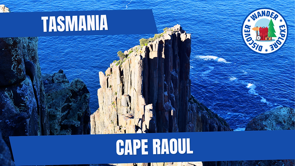
Cape Raoul is one of Tasmania’s most spectacular coastal hikes, located on the rugged Tasman Peninsula in the island’s southeast. Known for its towering dolerite cliffs, windswept headlands and sweeping views over the Southern Ocean, this walk showcases the raw, untamed beauty of Tasmania’s coastline.
As part of our mission to complete all 60 Great Short Walks of Tasmania, Cape Raoul marked our longest walk so far. At 14 kilometres return, it’s a more demanding hike than many others on the list, but the dramatic scenery, sense of remoteness and ever-changing coastal views make it an unforgettable experience.


Cape Raoul: One of Tasmania’s Great Short Walks
The Cape Raoul Track is officially recognised as one of the 60 Great Short Walks of Tasmania. While it sits at the upper end of the “short walk” category due to its length and difficulty, it rewards hikers with some of the most dramatic cliff-top scenery on the Tasman Peninsula.
The Walk Details
Distance: 14 kilometres return - Time: Allow 5 hours - Grade: Grade 4 (challenging)
At the trailhead, you’ll find an information board and a registration book. Take a moment to sign in, clean your boots and prepare for the walk ahead.
What to Expect on the Cape Raoul Track
The walk begins with sections of duckboard before heading uphill through stringybark and blue gum forest. The climb is steady but manageable, and after around 30 minutes (approximately 2 kilometres), you’ll reach the Cape Raoul Lookout, offering stunning early views of the coastline and the deep blue waters of the Tasman Sea.
From here, the track descends sharply towards Cape Raoul. This long, winding downhill section features switchbacks and steps and is particularly tough on the return journey. The effort, however, is well worth it.
As you move through sheltered forest, the track eventually emerges back onto the coastline, revealing expansive ocean views and dramatic cliff faces. Low coastal heathland follows, where you’ll start to see the striking fluted dolerite columns that define this wild stretch of coast.
The track then opens onto rocky sections with multiple lookout points — ideal spots to stop for a break, take photos and soak up the scenery.
Tarns, Heathland & Final Lookouts
Continuing along duckboard paths and through low-lying coastal scrub, the walk passes a large tarn. On our visit, it was full of water and made a beautiful contrast against the surrounding heathland.
Soon after, you’ll reach a sign offering two short detours — one to Seal Rock Lookout and the other to Cape Raoul Lookout. Both are around a five-minute walk and well worth the extra time.
Seal Rock Lookout
Seal Rock Lookout is a standout feature of the Cape Raoul walk. From this vantage point, you’re treated to panoramic views of the rugged coastline and sheer dolerite cliffs plunging into the ocean below.
On calm days, you can often see or hear seals resting on the rocks far beneath the cliffs, adding life and movement to the dramatic seascape. It’s a fantastic spot to pause, take photos and appreciate the scale of Tasmania’s wild southern coastline.
Cape Raoul Lookout
Cape Raoul Lookout is the crowning highlight of the hike. From this dramatic viewpoint, the sheer cliffs drop straight into the crashing waves of the Tasman Sea, with jagged headlands stretching into the distance.
The scale of the landscape here is breathtaking — towering dolerite columns, endless ocean, and constantly shifting light. It’s the perfect place to stop, catch your breath and reflect on the journey before beginning the long return walk.
Tips for Hiking Cape Raoul
• Register your walk: For safety, remember to register your hike at the information hut at the start of the track. This also helps park rangers keep track of visitors on the trail.
• Clean your boots: To protect Tasmania’s unique environment, make sure to clean your boots before starting the hike to prevent the spread of soil-borne pathogens.
• Facilities: Toilets are available near the car parking area, but there are no facilities along the track itself, so plan accordingly.
• National Park Pass: A valid Tasmanian National Parks pass is required to access the trail. Passes can be purchased online before your visit.
• Trail conditions and safety: The Cape Raoul track is longer and more challenging than many other short walks, with uneven surfaces and exposed cliff sections. Wear sturdy footwear, carry plenty of water, and check the weather before heading out.


How to Get to Cape Raoul Walking Track
From Port Arthur, follow the Arthur Highway until it becomes Nubeena Road. Continue along Nubeena Road, then turn left onto Stormlea Road.
Follow Stormlea Road to the end. The road is sealed except for the final kilometre. You’ll reach the carpark and the start of the Cape Raoul walking track.
Final Thoughts: Is Cape Raoul Worth It?
Cape Raoul is a challenging but deeply rewarding hike that showcases the Tasman Peninsula at its wildest. With towering sea cliffs, remote coastal views and a true sense of adventure, this walk is ideal for hikers looking to push themselves and experience Tasmania’s raw coastal beauty.
If you’re up for a longer walk and want some of the most dramatic scenery on the peninsula, Cape Raoul is an absolute must.
More Places to Explore
Tasman Arch, Remarkable Cave, Bivouac Bay, Pirates Bay, Fortescue Bay, Devil's Kitchen, Tessellated Pavement, Tasman Arch, The Blowhole, Crescent Bay, Fossil Bay Lookout, Coal Mines Historic Site, Cape Pillar and Cape Hauy.


Comments